Routes and Maps
The routes for the 2023 Million Dollar Bike Ride will start and finish at the University of Pennsylvania campus in downtown Philadelphia. The roads will be completely shut down for exit from the city, up until the MLK river drive. The return will stay on the river drives almost all the way until the South Street bridge, which will bring us over to the finish with very little time on streets with traffic for the short route.
Shown below are the 2023 MDBR routes. Route distances are approximate. Please note that there are time cut-offs for the long route. Time cut-off details can be found below.
***A note about safety: There will be a ZERO tolerance policy for cyclists not wearing a helmet. If you are seen not wearing a helmet, you will be stopped and asked to hand in your MDBR bib.***
Short Route
10 miles, total ascent 278 ft
Start time: 7:36 am
The 10 mile route includes a gradual climb route, but still designed for first time cyclists, younger cyclists, and cyclists who are looking for a shorter time commitment. Almost the entire route is flat, with one short climb on the in-bound portion of the route. Approximately 6 miles of the route occur on Philadelphia’s scenic MLK drive, which is closed to traffic on the weekends, which makes this route a great fit for novice cyclists who aren’t comfortable riding in traffic. There’s one rest stop, located at mile 4.2, which also serves as the turnaround point for riders on this route.
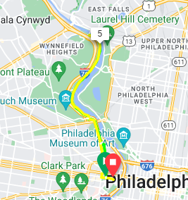
Click HERE for the 10 Mile Route rest stop map
Medium Route
32 miles, total ascent 1533 ft
Start time: 7:33 am
This 32 mile route is a great fit for the recreational cyclist who ride several times a week and have ridden this distance before. While approximately 6 miles of this route also occur on MLK Drive, the rest of the route takes place on roads open to traffic, some of which have narrow shoulders or no shoulders at all. This route contains approximately 1600 feet of climbing, and while not significantly hilly, there are several long, challenging climbs along the way. Stocked with a total of 4 rest stops (miles 4.2 12.5, 19, 27.3) this ride will take you on many of the roads that are most traveled by local cyclists.
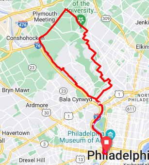
Click HERE for the 32 Mile Route rest stop map
Long Route
70 miles, total ascent 3606 ft
Start time: 7:30 am
The 70 mile route is a very challenging route designed for avid cyclists who regularly ride this distance. While approximately 6 miles of this route also occur on MLK Drive, the rest of the route takes place on roads open to traffic, some of which have narrow or no shoulders at all. Additionally, once the route turns off from the 34 mile route, many of the roads are country roads with few places to stop along the way. This route contains around 3700 feet of climbing and has several sustained climbs as well as a several very steep climbs. Stocked with a total of 6 rest stops (miles 4.2 12.5, 24.8, 45.2, 57.2, 65.2), this ride will take you on some of the most beautiful roads our surrounding suburbs have to offer. Because this route is extremely challenging, it is not recommended to those who have not ridden this distance several times before. Additionally, to ensure the safety of all of our riders and our support crews, there will be time cut-offs along the route that will be strictly adhered to. These cut-offs are based on a 7:30 am start time:
Mile 16 (turn-off for 32 mile and 70 mile routes) – 9:30 am – riders who do not make it here by 9:30 am will be sent on the 32 mile route
Mile 24.8 (Rest stop #3) – 10:45 am – riders who do not make it to mile 24.8 by 10:45 am will be asked to turn around
Mile 45.2 (Rest stop #4)– 1:00 pm – riders who do not make to this mile marker by 1:00 pm will be picked up by SAG support and brought back to the Start/Finish Venue

Click HERE for the 70 Mile Route rest stop map